West Highland Way: Trailblazer Ochils and Campsie Fells

 Bearsden & District

 Strathblane to Milton of Campsie

West Highland Way - Map West Highland Way: Footprint Map


Photographs of the Strathkelvin Railway Path beneath the Campsie Fells
 from Strathblane via Lennoxtown to Milton of Campsie


Kirkhouse Inn in Strathblane beneath the Campsie Fells

Kirkhouse Inn ( est 1601 ) in Strathblane beneath the Campsie Fells


Strathblane Parish Church beneath the Campsie Fells

Strathblane Parish Church ( built 1803 ) beneath the Campsie Fells


Signpost at start of the Strathkelvin Railway Path in Strathblane

Signpost at start of the Strathkelvin Railway Path in Strathblane ( opposite the Parish Church )


Ballagan Glen in the Campsie Fells from the Strathkelvin Railway Path

Ballagan Glen in the Campsie Fells from the Strathkelvin Railway Path


Cliffs of Dunglass

Cliffs of Dunglass

The remains of an ancient volcanic plug with typical ‘crag and tail’ features left by glacial movement.
 The ‘crags’ on the north and east sides are formed by glaciers scouring the hard igneous rock,
with the ‘tails’ on the south side formed by softer sediment on the leeward side of the crag.
Columnar basalt forms, similar to those of the Giant's Causeway and Fingal's Cave are to be seen.


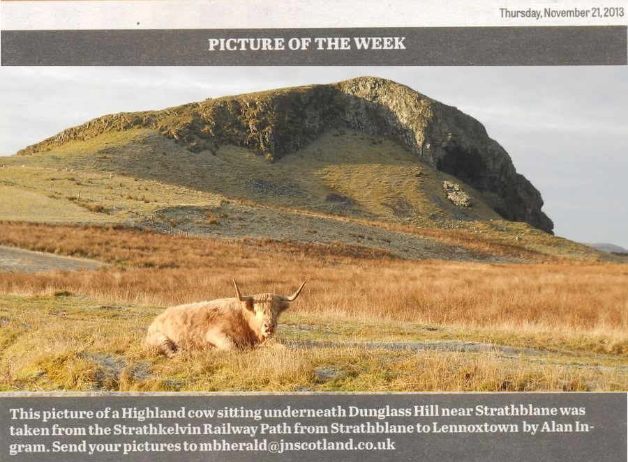
Highland Cow beneath Dunglass


Campsie Fells above Lennoxtown

Campsie Fells above Lennoxtown

Between Clachan of Campsie and Lennoxtown the route follows 
the Thomas Muir Trail


Glazert Water from the Strathkelvin Railway Path

Glazert Water from the Strathkelvin Railway Path


Campsie Fells from the Strathkelvin Railway Path between Lennoxtown and Milton of Campsie

Campsie Fells from the Strathkelvin Railway Path between Lennoxtown and Milton of Campsie


Road Bridge at Milton of Campsie

Road Bridge at Milton of Campsie


Glazert Water in Milton of Campsie

Glazert Water in Milton of Campsie


Shops in Milton of Campsie


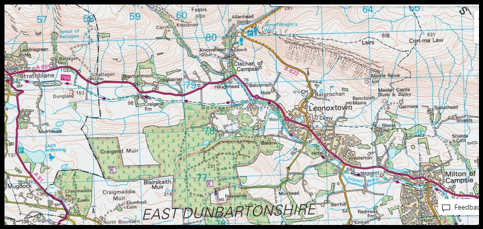
Map of the Strathkelvin Railway Path from Strathblane to Milton of Campsie

Map of the Strathkelvin Railway Path from Strathblane to Milton of Campsie


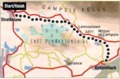
Route Map of the Strathkelvin Railway Path

Route Map of the Strathkelvin Railway Path


STRATHBLANE TO LENNOXTOWN WALK - ROUTE DESCRIPTION:

Thls walk takes us on a very pleasant stroll along the Strathkelvln Railway Path from Strathblane to Lennoxtown.
This is a beautiful walk along the valley of Blane Water with the return walk providing a different perspective of the nearby
Campsie Fells.
The walk gives a huge variety of scenery on a circular route, even though you are retracing your route.
The path has a tarmac surface and the total distance is seven miles and is a superb all-weather route.
The start of the walk is opposite Strathblane Parish Church on the A891 to Lennoxtown, about 100 yards from its junction beside the Kirkhouse lnn on the A81 to Aberfoyle.
There is ample parking next to the start. The No.10 bus from Milngavie to Balfron stops near the Kirkhouse Inn.
The path descends through a wood to join the old Blane Valley railway line. It used to link Strathblane with
Lennoxtown where it joined a branch of the Edinburgh and Glasgow railway and continued to Kirkintilloch and Lenzie.
The walk passes under two stone railway bridges on the way to
Lennoxtown. They are beautifully constructed and look to have the permanence of Roman structures.
A mile from the start you pass Dunglass, a basalt outcrop which shows that this area used to be the centre of volcanic activity.
The
Campsie Fells that form a barrier to the north are also of volcanic origin. You can see from the horizontal layers of rock on Dunglass and more dramatically on the exposed rock faces of the Campsies the successive lava flows that took place 300 million years ago, when the Campsie Fells were mighty mountains.
From time to time, the path is sheltered as it goes through old railways cuttings or past screens of hazel and silver birch. At other times it is surrounded by open fields and pastures. Among the trees there are lovely wild flowers and many small birds;  blue and long tailed tits, chaffinches and bullfinches. On the open land in winter you will usually see ducks and geese in the water-logged pastures and marshy land while in spring and summer you may see heron close by the Blane and hear the plaintive call of the curlew, more often heard than seen.
The path is straightforward to follow. At around the three mile mark it crosses the approach road to a recent housing development, Campsie Village. There you cross the road, turn right across a bridge and follow the sign; it changes its name here to the Thomas Muir Trail.
It is now a road, unused by vehicles, which shortly slopes up to the left.
Here you leave the Trail which branches to the left and continues through the old railway cutting.
Carry on up the road until it meets the A891 on the outskirts of
Lennoxtown.
Cross the road at the nearby pedestrian crossing and continue into the town, passing a pretty lochan, until you reach the Swan Inn at the corner of the road to Fintry.
On the return you will see the towers of Lennox Castle on the top of a ridge above Campsie Village.
You will experience different perspectives of the Campsies and it will bring home to you that the homeward stretch of a linear walk is quite unlike what you saw on your outward walk.


STRATHKELVIN RAILWAY PATH - ROUTE DESCRIPTION:

Location: Strathblane, Stirlingshire
Map: OS Landranger 64
Distance: 15 miles, ( 24km )
Tine: 1.5 hours
Terrain: flat; cyclepath

This excellent traffic-free cyclepath has been upgraded recently with a tarmac surface and provides a good cycling option, whatever the weather.
The path follows the trackbed of the former Gartness to Kirkintilloch Railway, which closed more than 40 years ago. It's practically flat and is ideal for young children.
Start from a small car park off the A891 by Strathblane, the Campsie Fells forming a pleasant backdrop on the left. Soon you'll reach a small rocky hill, Dunglass, on your right. This lump of basalt was quarried in the past - if you look closely you'll see columnar basalt forms, like those of the Giant's Causeway and Fingal's Cave.
Cycle on. by grassy fields, to Lennoxtown and Milton of Campsie.
Here, a plaque commemorates an early flight by the pioneering Italian balloonist Vincent Lunandi, who landed nearby in 1785 having launched from St Andrew's Square in Glasgow. His departure was watched by an excited crowd, one of whom was inadvertently lifted six metres off the ground before breaking free.
From the village the route swings south, running by the Glazert Water, to Kirkintilloch, where it links with the Forth and Clyde Canal.
Follow the cyclepath as far as you like, safe in the knowledge that the Kirkhouse Inn by the start in Strathhlane will provide a welcoming return.

Strathblane to Milton of Campsie Gallery Photo Gallery :: Strathkelvin Railway Path Gallery Photo Gallery

<< Back : Bearsden Walks Index : Next >>


Scotland Index :: Scottish Peaks :: Scotland Walks

Glencoe | Ben Nevis | Knoydart | Isle of Skye | Isle of Arran

The Eastern Highlands | The Central Highlands | The Southern Highlands | The NW Highlands


Adventure Travel : Worldwide Mountaineering : Site Index

fb icon  google+ icon Linkedin icon  twitter


Guide Books & Maps - Scotland:-


West Highland Way: Footprint MapWest Highland Way - Map West Highland Way - Map Western Scotland & the Western Isles OS Road Map Northern Scotland OS Road MapSouthern Scotland OS Road MapGlasgow Popular Hills - Map


Ochils and Campsie Fells

Glasgow Visitor Guide - Colin Baxter Itchy Insider's Guide to Glasgow Glasgow Footprint Pocket Guide Glasgow Insight Pocket Guide Glasgow Guide Pub Companion Glasgow Scotland's Highlands & Islands - Rough Guide Scotland - Rough Guide

Glasgow Insight Pocket GuideCollins Street Map of GlasgowGlasgow: Then & NowThey belonged to Glasgow Phillips Street Atlas of Glasgow & West Central Scotland Glasgow: The Photographic Atlas100 Hillwalks around Glasgow 50 Walks in Glasgow & SW Scotland

Visit Scotland - Touring Guide Scotland: Where to Stay - Hotels & Guest Houses Scotland: Where to Stay - Bed & Breakfast Rough Guide ScotlandScottish Highlands & Islands - Rough Guide Scotland - Lonely PlanetScotland's Highlands & Islands - Lonley Planet Great Glasgow StoriesGlasgow & Surroundings - Insight Guide

West Highland Way: Official GuideWest Highland Way: Rucksac ReadersWest Highland Way: TrailblazerThe West Highland WayWest Highland Way: Footprint MapWest Highland Way - Map West Highland Way - Map West Highland Way Wet Highland Way - Official Guide

Munro Almanac The High Mountains of Britain and Ireland The Munros: Scottish Mountaineering Club The Isle of Skye The Isle of Arran Wilderness Walks Ski Mountaineering in Scotland

More Wilderness Walks 50 Best Routes on Skye and Raasay Skye - W.A.PoucherMagic of the Munros Mountaineering in Scotland and Undiscovered Scotland by W.H.MurrayA Long Walk on the Isle of Skye

Classic Climbs - Central & Southern Highlands The Isle of Arran Lonely Planet, Walking in ScotlandPathfinder Guide: Skye and NW Highlands WalksPathfinder Guide: Fort William and Glen Coe Walks Rambler's Guide: Ben Nevis and Glen Coe50 Best Routes on Skye and Raasay - Chris Townsend


Google Analytics


Google Analytics

extremetracking
 eXTReMe Tracker


extremetracking
Sitelock caingram.com
SiteLock
Sitelock
Sitelock caingram.info
SiteLock
Sitelock