  |
Forth & Clyde
Canal
The Kelpies |
|
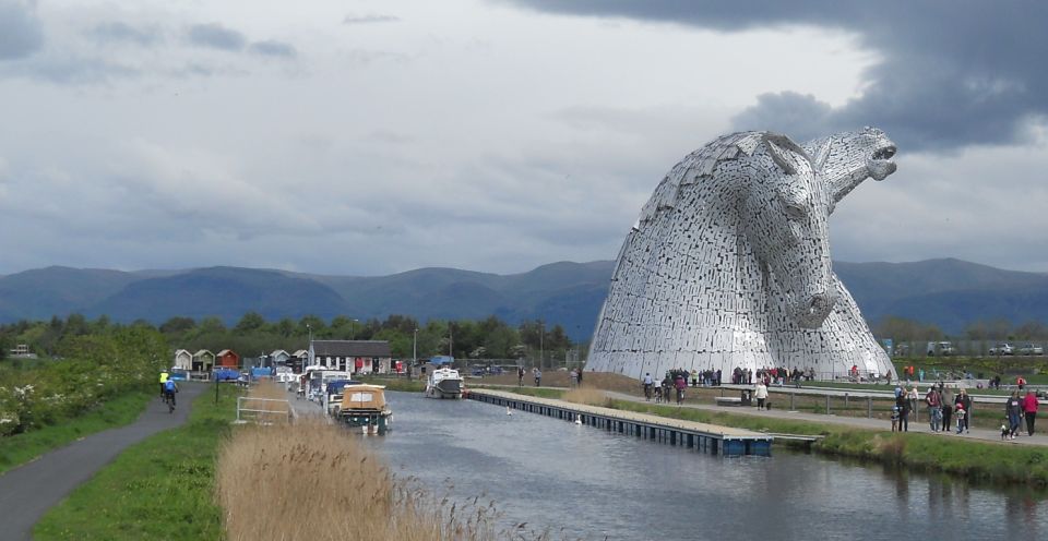
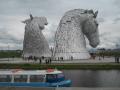
The 30 metre high Kelpies on the Forth and Clyde Canal The
Kelpies are a mythical, powerful, water horse
They represent the heavy horses once used to pull barges along the canal and also on farms and in industry.. |
 |
 |
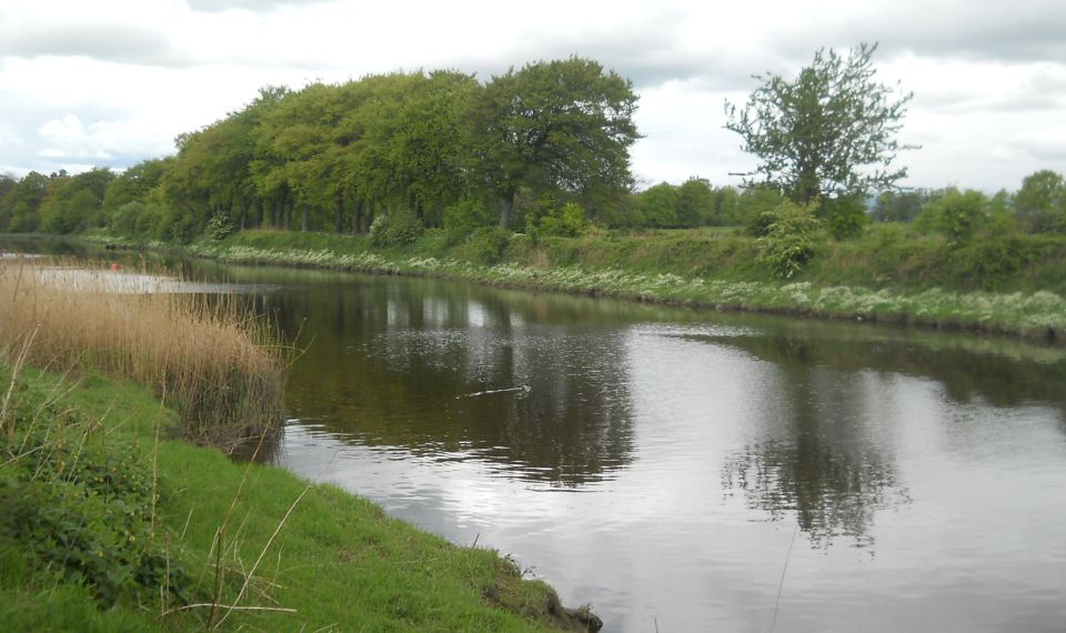
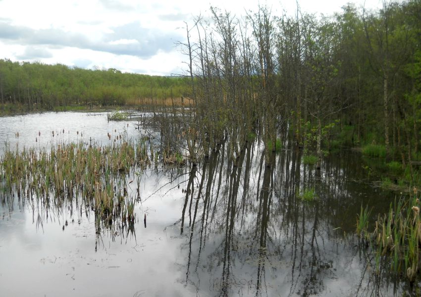
River Carron at the Forth & Clyde Canal |
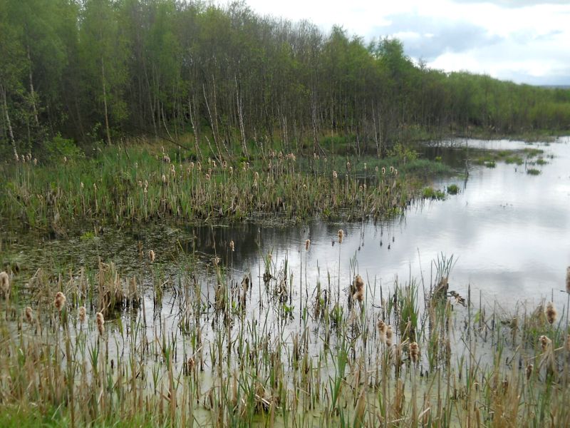
Wildlife Pond in Abbotshaugh Woodlands adjacent to the River Carron |
Wildlife Pond in Abbotshaugh Woodlands adjacent to the River Carron |
|
The
Kelpies at Carron
Sea Lock on the Forth and Clyde Canal |
|
One of the Kelpies on the Forth and Clyde Canal |
|
The Kelpies illuminated at night |
|
The
Kelpies illuminated at night |
|
The Kelpies illuminated in red for the Poppy Appeal |
|
The Kelpies at sunset |
|
Aerial view of The Kelpies |
|
Aerial view of The Kelpies |
|
Aerial view of The Kelpies |
|
Aerial view of The Kelpies |
|
Aerial view of The Kelpies |
|
Aerial view of The Kelpies |
|
Aerial view of The Kelpies |
|
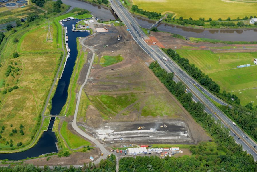
Aerial
view of The
Kelpies and Carron Sea Lock |
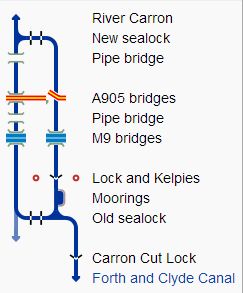 Map
of the Carron Sea Lock
|
 |
 |
 |
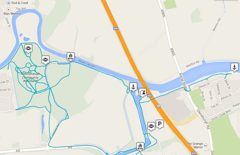
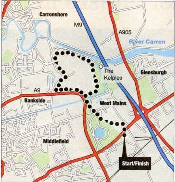 Route Map
of Walk around the Kelpies area |
KELPIES WALK - ROUTE DESCRIPTION:
Location: Falkirk
Map: OS Landranger 65 or Explorer 349
Distance: 4 miles ( 6km )
Time: 2-3 hours
Terrain: Easy low level walk
Public art can add interest and intrigue to any walk, and the central feature of this walk is as bold and brilliant a piece of work as you could hope to see.
The two massive horse heads known as the Kelpies are the central feature of a major redevelopment scheme known as the Helix which
is transforming a previously nondescript part of eastern Falkirk into a high quality recreational area.
The Kelpies are two 30-metre high metal sculptures by Andy Scott. They are hugely impressive close up, though they are a
wee bit misnamed — in Scottish legend kelpies, or water-horses, were sinister creatures which lured unsuspecting victims to a watery end in the lochs
they inhabited, whereas these two grey giants have an air of gentleness about them and are not in the least threatening.
The Kelpies are in Helix Park which also includes a lagoon where you can use canoes or simply sit and enjoy the water and a large grass area known
as the Great Lawn which will be used for live performances. It is surrounded by floodlights mounted on tall, elegant wooden structures that
look like giant needles. The Park also includes a wetland area, part of the original landscape. where you walk through a mass of graceful bulrushes.
Helix Park is being used by the very successful health walks programme known as Step Forth, which encourages everyone to add walking to their
regular activities and brings a new and healthier dimension to their lives. The program includes ‘buggy walks’ for young mums, walks for blind
people and Nordic walking sessions. Step Forth is supported by Paths for All.
This project extends out across the wider Helix area. which covers several parts of Falkirk and will in time include 27km of surfaced paths suitable for
all users. The Helix proiect has been Lottery funded and is already showing signs of becoming a great community asset for the area.
The walk described here also takes in Langlee Community Woodland, which includes an old orchard, and passes two further intriguing pieces
of art. The Sun Clock enables you ( when the sun is shining ) to stand on its central base and tell the time, and Love & Kisses is a cheeky piece of work
which might be a heart, or a pair of lips, or anything else you care to make it.
Note also that some of the Helix paths, including those in Helix Park, are not yet on OS maps but you can find more information on them on the Helix
website - www.thehelix.co.uk
Route:
From Falkirk Stadium car park, cross the main road at the lights into Helix Park.
Follow Kelpies signs north past the Lagoon and the Great Lawn and through the wetland area.
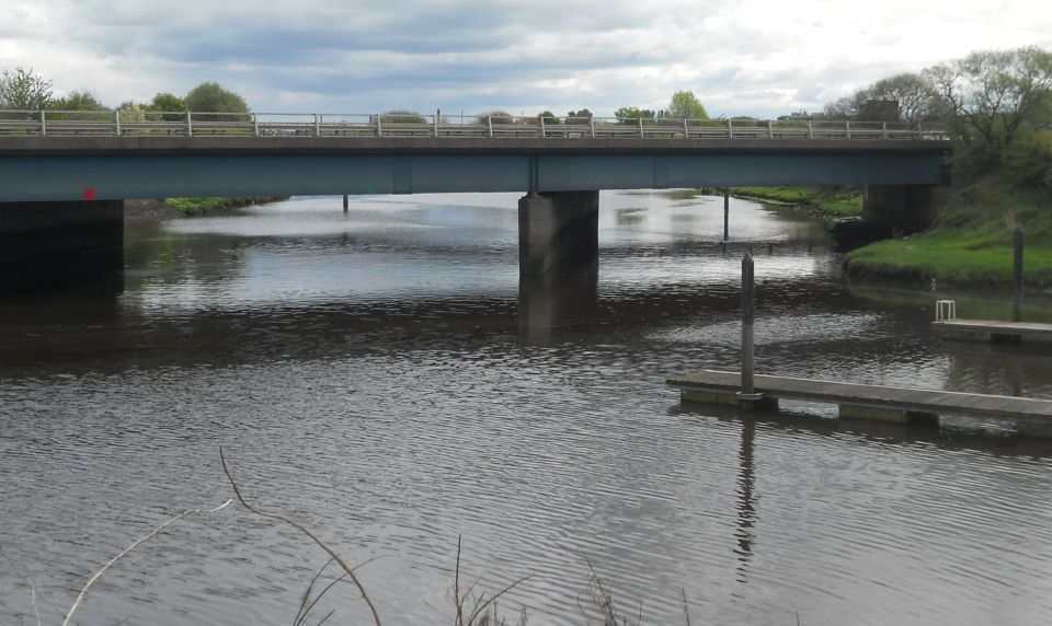
The route continues up to a bridge over the canal and on to the viewpoint.
Past the Kelpies take a path on the left ( signed Langlee Community Woodland ).
Follow this path through woodland to the Sun Clock.
A tarmac path ahead leads to Love & Kisses.
Return to the Sun Clock and go right on a broad path which comes out at an access road.
Turn right and at the main road go left and back across the Blue Bridge.
Then retrace the outward route to the stadium.
 Map
of Walk around the Kelpies area
|
KELPIES WALK - ROUTE DESCRIPTION 2:
Location: Falkirk
Map: OS Explorer 349
Distance: 3.5 miles ( 5.5km )
Time: 1.5 - 2 hours
Grade: Easy low level walk
Helix Park - previously an extensive tract of industrial land - is a pleasant park with a range of attractions for everyone to enjoy,
as was evident from the number of families. Going south to north you pass the Lagoon, which has a
beach, birdlife and a cafe, a brilliant children’s adventure play area, over the Great Lawn, through a wetland
area and on to the Helix Hub, which has a visitor centre, cafe, shop and displays.
All of this is leading you to the main attraction, the centrepiece of the whole area — the two magnificent
Kelpies sculptures of horses heads by Andy Scott. Thirty metres high and weighing more than 300 tonnes, each
is made from over 450 irregular steel panels. They represent not just the mythical Kelpies of Scottish legend,
also called in Gaelic each uisge or water-horse, which lured unwary travellers to their doom in remote
lochs, but also the horses which provided essential pulling power in this area at the time of the Industrial
Revolution, and of course towed barges along the canal beside which they now stand.
The Kelpies are in fact based on two majestic Clydesdales called Duke ( with his head down ) and Baron
( head up ) which lived and worked in Glasgow’s Pollok Park. Duke is still alive but Baron died earlier his year aged 20.
Andy Scott took these wonderful horses as his inspiration and has created a unique work of art, and indeed of engineering.
A tour can be booked at the visitor centre. Not only is this very informative, it takes you inside Duke
to see how the construction worked. It is like an amazing steel jigsaw, and you can only marvel at the way it all
fits together ( the original models or maquettes for the sculptures can be seen at the Falkirk Wheel ).
The Kelpies are central to the Helix project but under the overall control of Falkirk Community Trust this now
extends right across the Falkirk area providing an expanding network of paths and cycle trails.
Part of this may be used to extend the walk through the area known as Helix North which includes Langlees Community
Woodland, with a couple of intriguing outdoor artworks, returning to the main Helix Park area along the Forth and Clyde Canal.
The canal at present ends abruptly close to the Kelpies but there are ambitious plans to restore the final link, taking it out into the River
Carron and thus to the Firth of Forth as it did when it opened 200 years ago. This is called the Queen Elizabeth Canal providing another link
between the past and the present of this fascinating area.
Route:
Start and finish at Falkirk Stadium ( GH: NS907807 ).
When you enter the stadium car park, turn immediately right and park in this area.
The path to Helix Park is signed at the north-east corner of the car park.
From the car park cross the road at the lights to enter Helix Park.
Follow the signs up past the Lagoon and Great Lawn, turning right to walk through the wetland.
Cross another road and walk up beside the canal to see the Kelpies.
Walk right of the sculptures, pass the marina office and cross the canal at its outlet.
Turn left and follow the twisty path towards Langlee Community Woodland, walking beside the River Carron for some distance before swinging left into woods.
Pass the Human Star Clock and, at a junction, TR to see Love and Kisses.
Return to the junction and TR on a rougher path.
At the next junction keep ahead on a tarmac path just outside the woodland.
When this ends TR on a small road.
Cross the main road and walk down Abbots Road.
TL on canal towpath.
Follow the canal to Lock 3, cross and walk back through Helix Park to the start.
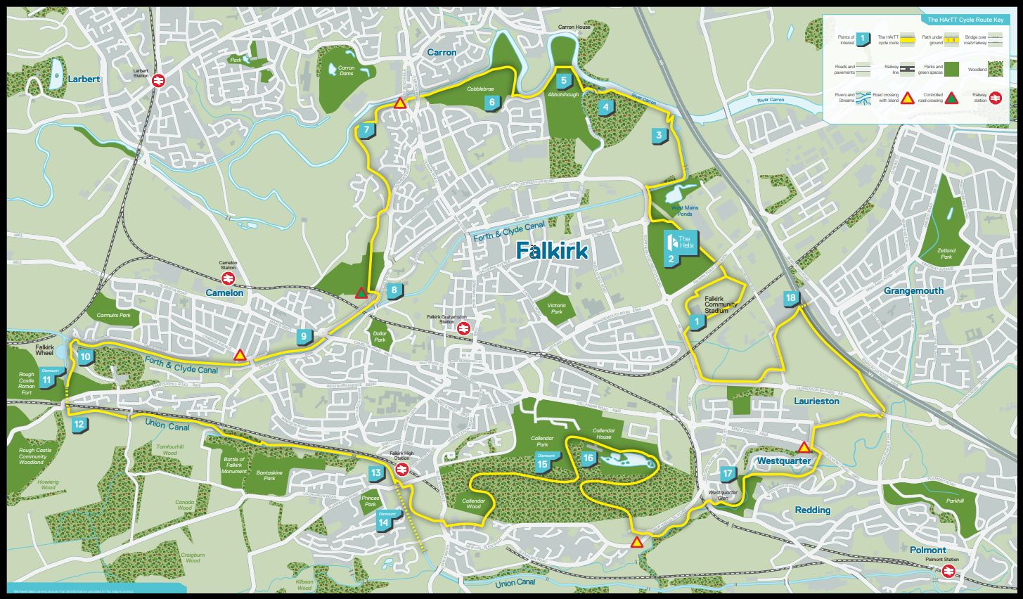 |
BIKE RIDE: HELIX AROUND TOWN TOUR - FALKIRK AND GRANGEMOUTH
Created out of 310 miles ( 500km ) of cycleway, this 16-mile ( 26km ) circular route begins at The Helix and travels past The Kelpies, The
Falkirk Wheel and Callendar Park.
The Helix Around Town Tour ( HArTT ) comprises a fantastic mix of cycleway, towpath and woodland trail with highlights that include
Abbotshaugh Community Woodland, home to art projects including The Human Sun Clock,
Celtic Circle and Love & Kisses.
Other delights to check out are Westquarter Glen, a hidden gorge with waterfalls, a stream and tree
species such as yew, sycamore, oak, holly and larch.
Bird lovers should keep their eyes peeled for dippers, grey wagtails, kingfishers, tawny owls and buzzards.
Visit Falkirk - Helix Round Town Route
 :: Forth
&
Clyde Canal Gallery
:: Forth
&
Clyde Canal Gallery 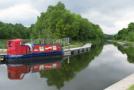
Glencoe | Ben Nevis | Knoydart | Isle of Skye | Isle of Arran | The West Highland Way
The Eastern Highlands | The Central Highlands | The Southern Highlands | The NW Highlands