1. By road from Kathmandu via Ilam to road-head at Phidim.
2. Phidim to Baranphung
Steep descent from Phidim past police checkpoint to rivers. Long gradual climb up through terraces to camp-site at school.
3. Baranphung to Sinam:
Climb up to ridge. View across to Jannu (Khumbakarna) and Kangchenjunga. Walk along road to Gopetar. Round hillside, contour round and down. Good views of mountains and route ahead up Kabeli Khosi valley. Steep descent to rivers and shortly up to camp in terraces at Sinam.
4. Sinam to Khewang:
Contour along and up, before descending to river. Long, steep climb up other side before contouring round forested hillside to open, flatter ground at Khewang. Camp in school grounds.
5. Khewang to Yamphudin:
Steeply up from village to col, down through woods then back up to other col. Steeply down through jungle to stream, terraces and some Sherpa houses. Along level ground to river and up stream and across bridge to Yamphudin. Camp in rice paddies. Police checkpoint.
6. Yamphudin to Dovan (Bheda Kharka):
Steep climb up from river to small cluster of huts. Continue up through jungle to col and down far side to river. Camp in clearing / kharka on far side.
7. Dovan to Simbua Khola:
Long steep climb up through mixed forest (fir, rhododendron) to top of Deorali Danda. Across level top (kharkas) to chautaara. Steep, narrow path leads from col down across landslips back into jungle. Continue down, across streams to river. Camp in kharka (clearing) on far side across cantilevered wooden bridge.
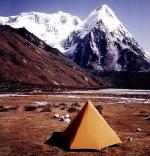
8. Simbua Khola to Tseram:
Gradual, pleasant, walk up through fir forest alongside / above river. Steep sided valley, rocky peaks above. View up valley to snow peaks. Short climb up to level, grassy meadows at Tseram.
9. Tseram to Ramze:
On up valley across side stream / gully. Through forest to open scrub, meadows. View up to snow peaks (Ratong, Kabru) at valley-head. Path continues beneath moraine of Yalung Glacier past small lake to extensive, level, meadows at Ramze beneath snow peaks to North. Climb up moraine wall for view across glacier to ice-fluted Koktang.
10. Ramze to Oktang:
Level walk across meadows to valley head beneath Ratong before turning northwards. Ascend crest of moraine to chorten at Oktang for view up glacier to Kangchenjunga. Eastern side of glacier dominated by 7000m snow peaks (Talung, Kabru, Ratong).
11. Ramze to Yalung:
Back down valley to side stream / gully. Climb steeply up far side to small terraces for camp-site.
12. Yalung to Sinian La:
Steeply up hillside to small lake. Spectacular view down into valley to glacier and snow, rock, peaks. Steeply up to col, ( Mirgin La ) with prayer flags, cairns. Continue round hillside. Long, high, level, traverse rising, falling to Sinian La. Spectacular view from col of Jannu (Khumbakarna). Descend from col to flats at stream in rocky amphitheatre for camp-site.
13. Sinian La to Gunsa:
Continue descending, traverse to lower col (Tama La - prayer flags / cairn). View across Gunsa Khola valley to Sharphu (snow and rock peak). Descend through forest (rhododendron / fir) to pleasant meadows at stream before reaching Sherpa settlement of Ghunsa in valley floor. Police checkpoint.
14. Ghunsa to Kambachen:
Up, steep-sided, forested valley alongside banks of river. Waterfalls. Rock and snow peaks above. Cross river on cantilever bridge and climb steeply up and across massive landslips. Contour along and then down to summer settlement of Kambachen at foot of side valley. View to South of Jannu, Phole / Sobithangie and Khabur. View up valley to Sharphu.
15. Kambachen to Lhonak:
Climb up from village, then contour along valley-side. Ascend over rough moraine / scree slopes to more level boulder fields. Continue gradual climb up to yak pastures of Lhonak. View across glacier to Kangchenjunga. Snow peaks up valley to East and ris above camp-site to South.
[ 16. Lhonak to Pang Pema (Base Camp):
Cross side river / gully and walk along level terrain to huts at yak pastures. Views past snow peaks up glacier to Kangchenjunga. Ridge above may be climbed for better viewpoint.]
17. Lhonak to Kambachen:
18. Kambachen to Ghunsa:
19. Ghunsa to Amjilassa:
Cross bridge to path northen bank of river. Continue down the narrow, forested valley through Tibetan settlement of Phere / Folly. Gradual descent terminated by climb up to small settlement. Thereafter path undulates and winds in and out to negotiate spurs. Final approach to houses of Amjilassa on narrow path on a steep hillside. ( Long day - better to camp beyond Ghunsa on previous day ).
20. Amjilassa to Shekathun:
Across steep hillside on narrow path. Long drop to river. Descend via small settlement to river then downstream to pleasant meadow at Shekathun for camp-site.
21. Shekathun to Chirwa:
Across to South bank and along to confluence with Tamur Khola. Round to suspension bridge / confluence with Simbua Khola. Alongside river through steep-sided valley to flat stretch before village of Tapethak. Thereafter undulating switchback to Chirwa. Rugged countryside.
22. Chirwa to Handiwa:
Continue down riverside crossing side spurs. Faint path across extensive landslips. After a narrow stretch the valley widens. Level approach to the large village of Sinwa. Climb above village before descending back to riverside. Along to Mitlung. Steep climb up from village, across huge landslip and deep ravine. Continue climbing on far side through village of Handiwa. Camp in terrace.
23. Handiwa to Taplejung:
Continue up through the extended Brahmin / Chetri village to more level stretch to further ‘suburbs’ of Handiwa. Cross extensive landslips to reach district headquarters of Taplejung.
24. Taplejung to Dobhan:
Descend through terraces, forests to Tamur river and across suspension bridge. Through lower part of village then up through higher part (Police Checkpoint). Camp in terraces above village. View up valley to Jannu.
25. Dobhan to Gorcha Gaon:
Day of continual ascent up hillside through terraces and farmhouses. View across to Junna and Kangchenjunga improves with altitude. Camp-site at settlement of Gorcha Gaon or further up hillside.
26. Gorcha Gaon to Gupha Pokhari:
Continue climbing up through forested hillside. Views of Jannu and Kangchenjunga on route. Across brow of hill and over flatter stretch to col. Contour down and around to Sherpa village of Gupha Pokhari on ridge-top beside small lake. Views across to Kangchenjunga Himal and panorama along northern horizon from Makalu through Chamlang to Number.
27. Gupha Pokhari to Chauki:
Along ridge-top with views of the Himalaya to the North. Descend from top after Lamo Pokhari. through forests to long grassy stretch to the houses at Sikdim. View to East of Kangchenjunga Himal. Continue on over grassy, level stretch to Chauki and on to nice camp-site on meadow in woods. View to Himalaya / Makalu to the North.
28. Chauki to Besantapur:
Path continues on flat stretch through woods before climbing up to a col with views of Kangchenjunga Himal to the East and Makalu, Chamlang to the North. Gradual descent from col through woods and meadows to road-head at Besantapur.
29/30 Besantapur to Kathmandu:
By bus via Dankutar and Daran.
NOTES:
1) The trek may also be done in the reverse direction starting from Basantapur.
2) The trek may be started and/ or finished at the airport near Tumlingtar
Site Index :: Adventure Travel :: Worldwide Mountaineering