"Good morning uncle, sunsai cha?", ( are you well ) greeted Lalu, "This morning no clouds". I looked out of my tent to behold a superb Himalayan panorama.
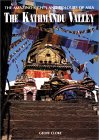
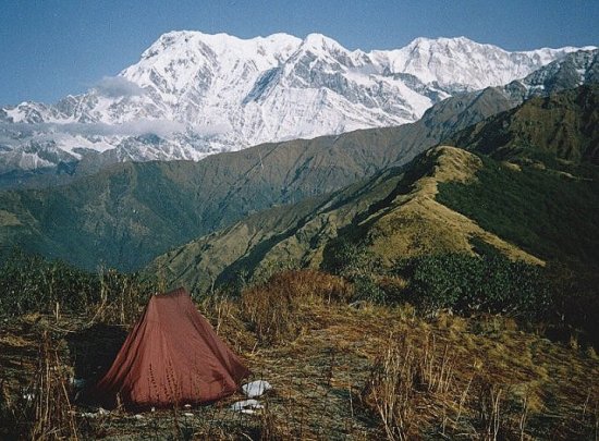 Annapurna South
and Annapurna 1 from Korchon |
We had left Pokhara some 2 weeks previously. On the outskirts at Bagat it had taken all morning to find porters familiar with our proposed route. Eventually we set off along the hot, dusty, new Chinese road beside the Yamdi Khola before heading northwards through the broad, flat, golden-yellow rice paddies to the small, compact village of Mardi Pul at the confluence of the Mardi Khola and the Seti Khola. We encamped on a grassy terrace across the river from the village.It was a fine starry evening and in the distance could be seen the shadowy forms of Annapurna South and Macchapucchre.
A snarling pack of guard dogs awaited us next morning when we crossed the rickety suspension bridge into the thatched roof settlement. We continued northwards up the Seti Khola valley through golden, rice paddies to the large Gurung village of Ghatchok. High in the sky amongst the cumulus clouds loomed the pointed summit of Annapurna IV.
Beyond Ghatchok we crossed the Seti river at Diphrang bridge and climbed along a forested ridge. Camp was made on the school volleyball pitch at Chyanglung village.
In the morning a flag-stoned pathway led up through the stone-walled, thatched-roof houses and then zig-zagged steeply to regain the ridge-top. A glimpse of the summit spire of Macchapucchre was briefly obtained before it was engulfed in the rapidly forming cloud cover.
We climbed along the ridge through meagre terraces of millet and small kharka (summer grazing settlements) with their wickerwork huts. There was a fine view down to the farms of Ghatchok scattered over a broad plateau above a double escarpment gouged out by the Seti river. At a grassy clearing in the scrub we stopped for lunch.
Leaving our equipment behind I searched with Lalu and Nima for an alternative campsite higher up the hill but failed to find another water supply. In the evening it rained heavily. Early next morning however,there was a clear, starry sky and I set off by torchlight for the top of Chyanglang Hill.
It was a 3 hour climb through dense, damp, moss-covered forests before I emerged onto open grassy slopes leading to the flat-topped summit. The promising start to the day was not fulfilled. Although it was only 0800hrs, clouds and mist already obscured the view. A short wait was rewarded with a sighting of the triangular, ice and rock peak of Macchapucchre in a window in the clouds. Other glimpses were then obtained of the nearby summits of Annapurna III and IV - sufficient to verify that on a clear day the outlook would indeed be spectacular.
 |
Returning to Ghatchok we set off the following day on the ascent of Odani Hill, the high point at the start of the long ridge falling from Macchapuccchre. Our objective was to reach the base camp situated beneath the peak on a hidden plateau - "The Other Sanctuary".
At a solitary farmhouse perched atop a narrow ridge we stopped for lunch. Large chil eagles wheeled and soared in the sky overhead. Further up we emerged from thick forest into an open grassy meadow at Hille - a nice campsite - apart from the leeches. In early morning sunshine a fine view obtained across the valley to the peaks of Annapurna IV and II and the broad massif of Lamjung Himal.
A short, half day, climb gained the ridge-top where we immediately encamped as the next water supply was too far for the day. Once again cloud and mist had enveloped the tops.
Clear skies at dawn revealed the dazzling white of Annapurna South and the Hiunchuli peaks a short distance away to the northwest of our ridge. Their features were mirrored clearly in the dark, still waters of the small pool at our camping place.
The long, gradual ascent along the forested ridge-top, with occasional views on either side down to the valley floors, was abruptly terminated with a steep climb out of the jungle to reach the green, grazing pastures on the hilltop at Kumai. Again water supply was a problem and we dropped down a short way to encamp in a pleasant glade in a birch forest.
Another fine view in the morning revealed Macchapucchre rising at the head of the ridge and Annapurna IV, and II, and the Lamjung Himal off to the east.
Regaining the crest of the ridge another, longer, steep climb over tussock grass slopes, brought us to the level pastures of the kharkas at Khorchon and a magnificent panorama to the west of Annapurna South, Annapurna I and Hiunchuli.
Setting off early next morning we followed the crest of the ridge passing more kharkas, now deserted for the winter, and some moss-covered pinnacles before climbing sharply to a transverse ridge. The new ridge led upwards to a narrow path which then contoured round the steep hillside. At a junction the right-hand path led slowly up to a col with a single cairn. According to the guidebook we should have now reached the next campsite. No possible site was found. We retraced our steps to the junction and Lalu and I investigated the left-hand path. This also led to a col but again no possible campsite was found.
The weather had deteriorated throughout the morning and it was now cold, cloudy and windy. Light snow was falling and we retreated back to our previous campsite at Khorchon.
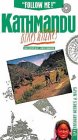
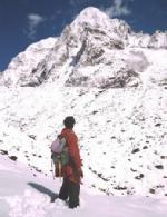
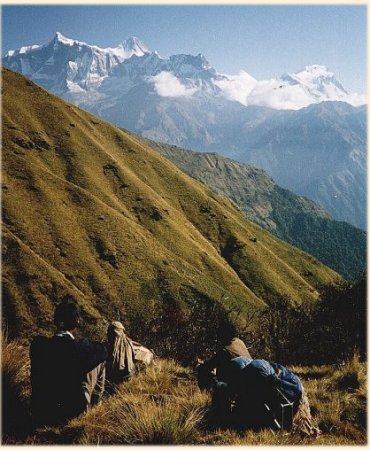
 Mardi Himal
and Macchapucchre from Khorchon |
A winter's scene greeted us in the morning with the landscape blanketed with snow. The tops were shrouded in cloud. A rest day was spent mostly inside the tents. The day after was still overcast but I set off back up the ridge. Lalu and Nima were to follow bringing a packed lunch while our two porters were to remain in camp.
Regaining the junction in the path, I followed the left-hand branch back to the col and then onwards on a narrow path round the base of the rock and snow slopes of Mardi Himal. After some time I decided I was getting nowhere and returned to the junction where I was joined by Lalu and Nima. We now pursued the right-hand path. Shortly after the col a faint track was found which contoured to the left across the mountainside. This led onwards and upwards to another col with 3 cairns. A boulder field was then crossed leading to a flat snow-covered meadow with some old, roofless, stonewalled huts were found - presumably the "Other Sanctuary". Disappointingly, with the enclosing clouds, no view of the surroundings was possible. Again we retreated to our campsite on the hilltop at Khorchon.
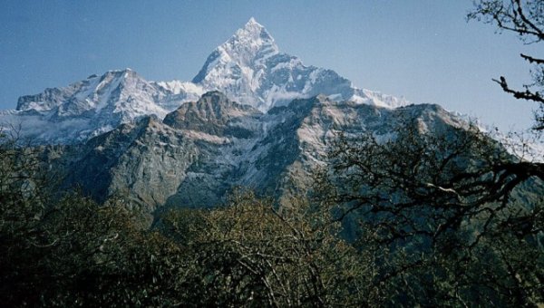
It was the following morning that a brilliant red sun climbed over a pink horizon into a cloudless sky. To the east were the silhouettes of the peaks of the Manaslu Himal. Closer were the summits of Annapurna IV and II, and the Lamjung Himal. Soaring directly above us towered the rock and ice ramparts of Macchapucchre. To the west were the dazzling white snow slopes of Annapurna South and Hiunchuli.
By 0830hrs however, banks of clouds were already materialising and we started our return down the long ridge back to the jungle. Occasional shafts of sunlight penetrated the dense canopy resounding with a crescendo of chirping and buzzing insect life.
From Odani Hill we descended on the western side through the Gurung village of Riban on a long stone stairway and across the rice paddies to encamp on grassy flats on the banks of the Mardi Khola.
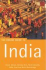
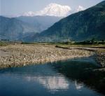
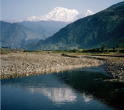 Annapurna South
from Modi Khola |
There was a fine view up the valley in the morning to Annapurna South and Hiunchuli. The path now followed the banks of the river back to Mardi Pul and the confluence with the Seti Khola where we again sighted Macchapucchre, Annapurna IV and Annapurna II.
Proceeding through the rice paddies alongside the Seti Khola we soon reached the outskirts of Pokhara and a local bus brought us back to our hotel in the city centre.
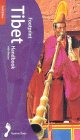
From the flower gardens at the dam on Phewa Tal the next day there was a splendid outlook across the lake to a splendid Himalayan panorama extending from Dhaulagiri in the west, through Annapurna South and Hinuchuli, Macchapucchre, Annapurna III, IV and II, and the Lamjung Himal to Manaslu in the east.
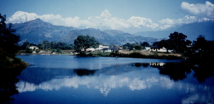 Annapurna Himal
from Phewa Tal in Pokhara |
A 9 hour bus journey over the broken, pot-holed, 200Km road, in a perpetual state of reconstruction, brought us back to Kathmandu.
Himalaya Map - Nelles ( UK , USA )
Nepal Trail Map - Nelles ( UK , USA )
Everest Base Camp Map ( UK , USA )
Khumbu Region Map ( UK , USA )
Island Peak - Climbing Map ( UK , USA )