The 220 mile trek
around the great, semi-circular,
multi-summitted Annapurna
Massif takes some 20 days to complete and is one of the
classic
journeys through the Nepal
Himalaya.
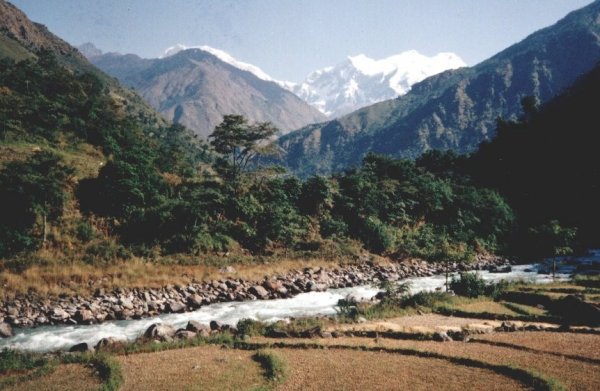
Starting amid lush, sub-tropical
rice-paddies the
route
follows the course of the Marsayangdi Khola ( river ) on
primitive trails through small farming settlements and alpine
forests of fir and pine to the arctic tundra of the yak pastures
surrounding the medieval village of Manang nestling beneath the
huge ice-fall tumbling from the giant, 7000
metre Gangapurna.
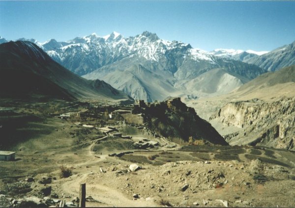
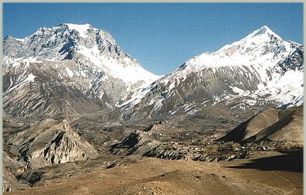
Beyond Manang the crux of the trek is
the
high-level crossing
of the snow-covered Tharong La to reach an arid, wind-swept,
mountain-desert region in the upper
valley of the Kali Gandaki.
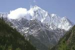
Upper Kali
Gandaki Valley
on descent from Tharong La
From the sacred temple at Muktinath
the return leg
heads
down-river on the trade
route from Tibet via the caravanserai of
Jomson and Tukuche through the deepest gorge in the world between
the two 8000
metre peaks of Annapurna
( the world's 10th highest mountain ) and Dhaulagiri
( the world's 7th highest mountain ) to finish at Phewa Tal (
lake ) on the outskirts of Pokhara - the second city of Nepal.
It was my first visit to Nepal and at
our trek
starting point
at the ancient royal city of Gorkha ( the origin of the illustrious
Gurkas ) I suffered from both anticipation and apprehension of
what was to follow. The thought of being up to 10 days away from
the nearest roadhead was daunting - in Scotland
and the
Alps
the most had
been only a couple of days. Another member of our group, Judith,
a doctor from the USA,
was also concerned and her backpack was extra heavy with
medicines squeezed in around her clothes and snowshoes
for all eventualities.
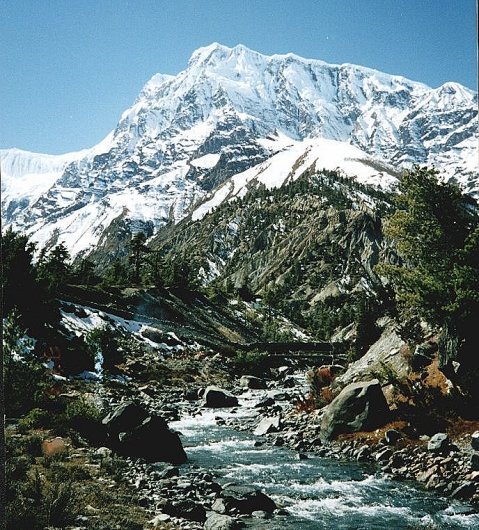
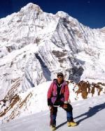
Annapurna III
from Manang Valley
As we headed up the scenic
valley on narrow trails
beneath
high rock walls and lofty snow peaks, criss-crossing from bank to
bank on long, swaying, suspension bridges, the tension in our
party increased as we progressed towards the huddle of
flat-roofed houses of Manang. Rumours circulated of an early
snowfall blocking the pass, disconsolate trekkers were met
returning having been defeated by altitude
sickness.
Our group leader, Phil did not help
morale; " If
you
don't make it over the pass you won't see your kitbags, being carried
by our porters, again until Kathmandu!".
My daysac was therefore at its heaviest
for the
1000 metre
climb over steep scree and snow slopes to the col at 5500 metres
- some 2,000 feet higher than my previous best on 4800 metre Mont
Blanc.
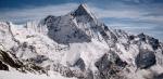
Tharong La and
Tharong Peak
on descent from Muktinath
However, by late evening, everyone,
including Jack,
a
60-years-old Irishman, had successfully struggled into the
walled, fortress-like camping ground at Muktinath. We had enjoyed
perfect conditions but others have not been so fortunate. On a
previous occasion a party of four Sherpas had died in a vain
attempt to secure help for their group snowbound on their attempt
at crossing the pass. Poorly clad porters have also succumbed to
exposure and hypothermia.
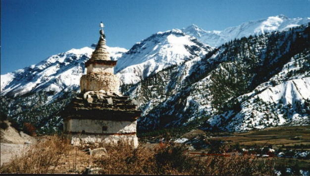
From the pagoda-style temple with its
sacred water
spouts and
natural gas flame a dramatic view unfolds of the barren moonscape
of the upper Kali Gandaki valley and the huge, white dome of Dhaulagiri
looming far to the south.
The numerous small, simple lodges in
the Kali
Gandaki valley
originally served as overnight staging posts for porters and pony
caravans carrying goods on the trade route to and from Tibet but
are now the haven of 'tea-shop' trekkers and the route between
Pokhara and Jomson, the most popular in Nepal, is now known as
the 'Coca-Cola trail'.
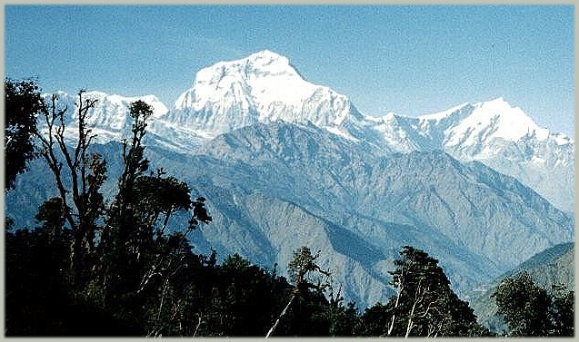
A long uphill slog from the riverside
at Tatopani
to the col
at Gorapani is alleviated by superb views of Dhaulagiri
and its neighbouring Tukuche Peak rising sheer above the valley
floor. Poon Hill, a short climb above Gorapani, provides an even
better vantage point to witness the great peaks flame red in the
rays of the rising or setting sun.
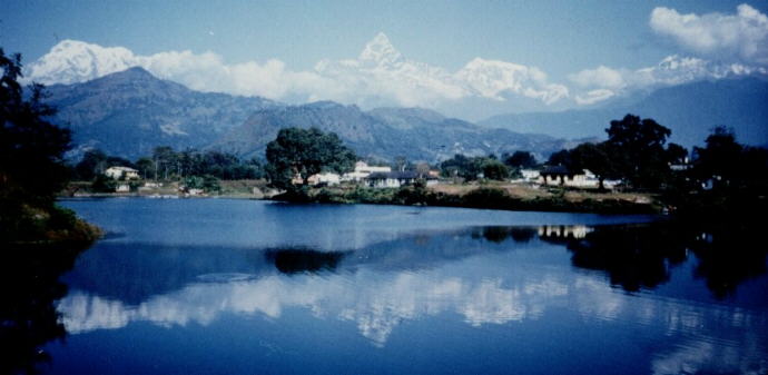
However the finest panorama is saved
for the end of
the trek
in Pokhara. On a clear day, from the dam on Phewa Tal, the entire
northern horizon is lined with mighty peaks ranging from Dhaulagiri
in the west through Annapurna South Peak, Hiunchuli, Annapurna
I,
Macchapuchre
( the 'Fish-tail mountain' ), Annapurna III,
Annapurna II and Lamjung
Himal terminating with Manaslu
Himal
in the east.
As customary our trekking crew and
porters were
well rewarded
with generous backsheesh ( money presents ) for their stalwart
efforts in ensuring the success of our trek while our sirdar Ang
Jangbu drew lots to allocate the donations we also made of
clothing and trekking gear. Most, but not all, of Judith's
medicines had been used to treat local villagers in evening surgeries
at our camping places .
Article in the Milngavie & Bearsden
Herald, January 15 1988:-
Alan
Ingram of North Grange Road, Bearsden has just returned from an
adventurous trip in Kathmandu trekking through the
Himalayas and around Annapurna. Ventures such as this are not new to
the intrepid Alan who was once a Venture Scout unit leader. Alan has
sent reports to the Herald of venture Scouts visits to the Alps among
others.
Alan was educated at Allan Glen’s School in Glasgow and graduated from
Glasgow University with honours in Physics.
Among appointments since then he has been senior lecturer in Computer
Studies at Bell College, Hamilton, and Chief Examiner with
Scotvec. Alan gave the following account of his recent trek in the
Himalayas to the Herald.
From Kathmandu it took nine hours by bus over rough pot-holed roads to
reach Gorka, home town of the Ghurkas and the starting
point for our 23-day trek around the Himalayan range of Annapurna. The
route followed one river valley, the Marsyangdi Khola, upstream to the
village of Manang, then over the snow covered Thorung La pass at a
height of 17,700 ft. (5500m) and down a second river valley, the Kali
Gandaki, to the town of Pokhara to complete the 220 mile circuit of the
8000m high massif of Annapurna.
The trek was in the classic expedition style. Our group of l4 trekkers
( two Scots, two Americans, one lrish, nine English ) were the
‘clients’ supported by the Trekking Crew. The Sirdar, Ang Jangbu, was
in charge of the trekking crew which comprised a team of
Sherpas, the cook squad and a team of porters. Our five Sherpas were a
cheerful, friendly, seemingly indefatigable group who acted as guides
during
the trek: one leading the way, two in the middle of the party, and two
at the rear acting as “sweepers” to bring in tail-enders. They also
pitched and took down the tents and acted as “waiters” in the mess tent
at meal times.
Although the porters were somewhat diminutive in stature they carried
prodigious loads of around l00lbs, eg three kitbags of 30lbs. Each huge
load was surmounted by a small bag containing their own meagre personal
items. At the start of the trek the porters numbered 36 but, as our
food supplies were consumed, they were paid off until only 14 remained
at the end in Pokhara.
The cook and his four cook boys were the busiest members of the party.
A typical day would begin at 6am with “bed—tea“ being
served in the tents by the Sherpas. This was followed by basins of hot
water for washing. Breakfast was served at 7am but only after
all kitbags had been packed, the tents taken down and the porters loads
made up.
The daily trekking started with a walk of about an hour and a half to a
convenient tea-house until overtaken by the cook squad who proceeded
ahead. A further 2 hours walking reached the selected spot where the
cooks were already preparing lunch. In the afternoon the same pattern
was repeated before reaching the night’s campsite. Tea was served soon
after arriving in camp to be followed by dinner in the mess tent at
about 1800
hours. As darkness soon fell most of us retired before 20.00 hours.
We were extremely fortunate to have an excellent chef ( Dendi ) who
managed to produce some incredible masterpieces from his open
wood fireplace. Other parties we met were not so lucky and complained
of never changing meals of rice and dhaal (a lentil sauce), the staple
diet of
Nepal. A wide variety of climate and terrain was experienced on the
trek. From Gorka the trail led through warm, humid, sub-tropical
forrests and extensive rice fields. Numerous primitive villages with
thatched roofed houses were passed where we were greeted by
youngsters with shouts of “Namaste (hello)” and “Have you a pen”. The
development of Education and a Health Service are
currently two of the major priorities in Nepal. (Two of the things
taken for granted in this country). The extent to which a Health Service
should be provided is a matter of debate, at present, it is very much a
question of survival of the fittest.
As we progressed upstream and gained height the valley narrowed, the
rice fields became terraced, many spectacular waterfalls
were seen and many long suspension footbridges had to be crossed. The
alarming amount of swaying was augmented on some of the
older bridges by missing or broken planking. At times the track was a
narrow stone stairway winding up and down hills or along
cliffsides overlooking raging torrents in deep gorges far below; at
other times a broad flat path through wide valleys with the river
flowing quietly.
After several days walking we had reached a height of over 2000 metres
and the scenery was now Alpine in nature: green grassy meadows, pine
forests and views of snow capped peaks. The influence of nearby Tibet
was also becoming apparent. Stone built flat roofed houses, mani walls
with prayer wheels or stone prayei; tablets, chorten in the forms of
archways at the entrance to villages and brightly painted gompas
(temples) with their white prayer flags were much in evidence.
At this stage our porters were issued with their cold weather clothing.
This consisted of white woollen hats, gloves and socks, heavy shirts
and long
trousers of local tartan cloth, and a pair of green canvas boots.
Hitherto they had been in shorts and most had been barefoot.
The scenery on the final days approach to Manang at the head of the
valley was magnificent. Reaching a col a vast panorama stretched
out ahead. The giant peaks of the Annapurna massif towered above on the
southern side while on the Tibetan northem side the
arid, sparsely vegetated valley was bounded by weird cliffs of yellow
rock eroded into dramatic pillars. Further up the valley a huge ice fall
descended to the village of Manang from the 24,000 ft. summits
immediately above.
ln Manang we made our l0th camp. The village was a compact group of
some 500 flat roofed stone houses separated by narrow snow-filled
alleyways. As with other villages we passed through an impression of
living conditions prevailing many hundreds of years ago in mediaeval
times was
gained. It was cold and dismal when the sun went down.
Leaving Manang we encountered groups of despondent trekkers making
their way back down. Some had suffered from high altitude
(mountain) sickness and could not risk going any higher. Other groups
were frustrated in their ambition to cross the pass by their
porter’s refusal to endure the cold and the snow. We had also heard
reports of the pass having been blocked by heavy snowfall
a week earlier with rumoured fatalities and trekkers getting trapped.
However we were to be for-tunate in all respects: in having ideal
conditions; in enjoying a good rapport with our porters; and in
suffering no adverse effects from the altitude.
The trail from Manang towards the pass was steeply ‘uphill but frequent
pauses were made to look back on the grandeur of the
Annapurna massif to the South. Higher up we admired the majestic flight
of lammergeirs as they soared overhead. A second days climb over a snow
covered trail through a narrow rocky valley brought us to our highest
campsite at the hamlet of Phedi at an elevation of 4420m (l4,500ft).
An alpine start at 0200 hrs. was made and we set off under a clear
starry sky with a full moon but in sub-zero temperatues. After a
five hour climb up steep scree and snow slopes the summit of the
Thorung La pass at 5500m (l7,700ft) was reached at 0700 hrs. just as
the first welcome rays of the rising sun were striking the tops of the
surrounding peaks. The barren Kali Gandaki valley, our return route
South, was
to be seen in the distance far below. Our leisurely descent to the
pilgrimage town of Muktinath included a rest at a nicely positioned tea
house.
Only recently have trekkers been allowed access to Muktinath which is
of major importance to both Buddhists and Hindus having gompas and
pagoda
style temples for both religions. An interesting aspect of Buddhism is
that there is no word for “thanks” in the Nepali language. Any
gift of clothing made to a porter was received with total impassivity.
It is deemed the privilege of the giver to have anything to give and
also to increase
prospects for achieving Nirvana. However gratitude was later made
abundantly plain in other ways - broader smiles of greeting, extra
assistance in
packing and unpacking of kitbags.
From the walled temples a fine view of Dhaulagiri, another 8000m peak,
standing in splendid isolation to the West of the Annapurna range, was
obtained.
We descended from Muktinath along a windy, dusty track through a harsh,
arid moonscape of yellow, desert-like hillsides with strangely eroded
rock
formations, to the broad, flat, washed-out valley floor of the Kali
Gandaki which led to the town of Jomson.
lt was only at Manang and Jomson that it would be possible to evacuate
any casualties as only at these two places are there STOL airstrips.
All other villages could only be accessed by foot or horseback.
At Jomson there was another checkpoint for our trekking permits at the
local police station. The allocation of permits is used
to restrict the number of trekkers in any region of Nepal at any given
period.
The trail continued to follow the Kali Gandaki downstream passing
closely below Dhaulagiri and its icefall, then through a deep
narrow canyon before diverting towards Pokhara.
We were now travelling across the “grain” of the country and two days
of steep uphill climbing was followed the next day by
6000ft. of vertical descent. A long pleasant walk along a ridge, giving
views of the southern aspect of the Annapurna peaks, followed
by a last downhill stretch and a canoe trip across the lake brought us
to the end of our 220 mile trek and final campsite in Pokhara.
The following morning our remaining porters were paid off and
handsomely rewarded with generous tips in appreciation of their
efforts. They departed well pleased after handshakes all round to start
another trek that same afternoon.
Donations of climbing gear and clothing were sub-divided by the Sirdar
and allocated amongst the Sherpas and cook squad by
means of a numbered draw.
On our last evening in camp we were entertained by a display of
traditional Sherpa singing and dancing to conclude a memorable
experience of a land of wild mountains and gentle, people.
Note:-
Detailed information ( Map, Itinerary, Route Description )
and a full set of photographs are available on CD Rom